|
Lost portages of Irvine
Lake A solo canoe trip into Woodland Caribou Provincial Park by Martin Kehoe Part 3 "20 Meter" Lake - Bluegreen Lake - Northeast to Irvine Lake GPS Waypoints Listings at the bottom of the part 8 |
|
Lost portages of Irvine
Lake A solo canoe trip into Woodland Caribou Provincial Park by Martin Kehoe Part 3 "20 Meter" Lake - Bluegreen Lake - Northeast to Irvine Lake GPS Waypoints Listings at the bottom of the part 8 |
With step one of the plan completed an attempt was made to find a way to get to the lake north of the 375 portage on the Royd to Murdock route. Many trips were made to the other lake and back and each time the route was better but still not good. The heat was still oppressive so bedtime swims were needed to cool my body enough that sleep was possible. Since there was somewhat of a route set up the portage was made to the lake north of the 375-meter portage. After three roundtrips on the beast, it was certain that a better route had to be found to the south.
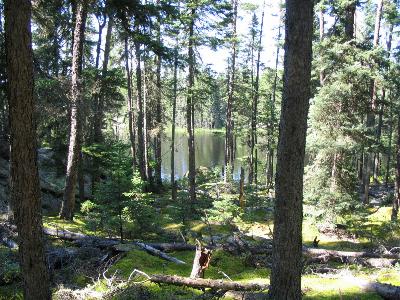
Camp was set up on the northeast end of what will be called "Salamander Lake." Paddling along the south shore it was obvious the flat open forest would provide a much nicer portage directly from Blue Green Lake, which lies between the 375 and 275-meter portages on the Royd to Murdock route. It turns out there is a perfect rock landing spot across the water from the 375 meter portage. From there the route goes through a flat, open forest of 12 inch Jack Pine. A route that is in sharp contrast to the terrain 2 kilometers to the north.
 |
 |
| Campsite at the start of the portage | Portage from Bluegreen Lake |
With another connection made it was time for an afternoon paddle around rarely observed "Salamander Lake." If anyone had been on the lake in recent years, they had left no sign of their passing. During the relaxing paddle, another meal of fish was procured for a much-enjoyed meal at the end of a very productive day. The portage from Blue Green had come so easily that I was anxious to start on the next quest. The next lake lay a kilometer to the ENE and the portage had to start in an area of heavy blowdown. After some research and planning with the GPS, the exploration began. It was a pleasant surprise that after 200 meters of blowdown my selected route entered an area of long open rock runs. One of these runs took me to an easy downhill passage to the next lake. Finding these great travel ways was very encouraging. When a route is found, it is just a matter of walking the area a few more times and adjusting the course to end up with the finest solution. So far, there have been no bogs to cross and all the portages start and end on excellent launching spots.
My days were broken up into a variety of activities. The pursuit of lost portages was the most fun but progress was going much faster than anticipated. This allowed ample time to sit back in camp and soak in the peace of the lakes and forest. The birds kept me attentive to their movements. Boreal Chickadees are always a special treat and an Osprey hunting your lake is very entertaining. Caribou sign was sporadic and a shed bull Caribou antler on the last portage was quite a discovery.
Some blowdown had to be cut to allow a safe passage to the open rock runs. My camp would not be moved until another day but to make it little easier the canoe and some gear were taken over in the evening. The allure of unexplored waters enticed me to launch the canoe upon reaching the shoreline. The maps show no inlet or outlet to this amazingly clear lake. The water is so high this year that water is flowing out a 10-inch hole in the solid rock shoreline on the northeast shore. It looks like it normally seeps out under the rocks and forms a small stream flowing to the next lake. There were only two choices for routes to the next lake across a narrow band of land. The best starts and ends on flat rock and is level all the way across the band. The other possibility was further east but went though some bog. This possibility did start out on a very sandy shore that would make a fun play ground at normal water levels. The impromptu exploration took longer than expected but the round rock structure in the southeast corner had me thinking of a fish breakfast.
It rained some in the night and caused me to linger a little longer under the tarp before striking out with another load of gear. A number of walks across the portage made it no easier to follow the proper rock run to the other side. In the forest, the moss can be scuffed enough to mark the way but the open rock required sharper attention. Spruce Grouse in the area assisted in getting my mind off the correct trail too. The fishing gear was laid out before launching the canoe. My lures were put everywhere from the round rock structure to a 20 meter hole on the east end of the lake with no results. The gulls and loons on the lake assured me that the problem was my fishing skills and not caused by a sterile lake. After giving up and landing on the big rock shelf at the portage one final cast provided a perfect Northern for brunch. It had been a fantastic morning but now the skies were telling me to get across the next lake.
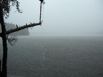 My wife sends me weather forecast in text messages on my satellite phone. Today’s forecast is for 90 degrees F and thunderstorms. Tomorrow is for 67 degrees and light rain. With that in mind, a camp is selected on the west end of the lake in a protected spot. Things are set up quickly and a nice swim is enjoyed before the weather changes. The sun is shining but thoughts of a paddle around the lake are set aside because of the whitecaps that have suddenly stated racing across the lake from the east. A little cool air is felt and then the storm arrives. The roar could be heard as the winds approached from the west. The tarp had been put up in fair weather with enough room to stand up. That allowed the wind and heavy rain to blow right through. During a lull, the tarp was changed to more of a lean-to. The effort was worth it for the storm raged for three hours. The storm was violent with frequent thunder and trees crashing down in the woods behind me. Fortunately, it was still quite warm so my soaked condition did not matter. By 5:00 the calm sessions were longer and then it settled down to a light shower.
In a light rain, a journey was made to check out a stream that flowed out of this lake and eventually ended up in Irvine Lake. A lot of water was spilling into the stream but it was not a possible route. The channel was brush choked and it looked like when the rain stopped the stream would too.
 With that option off the table, an exploration was made straight north form the northwest bay on the lake. A game trail led me to the next lake but left me far above the water on steep smooth rock where one slip meant disaster. Further study of the topo maps led me to try a route to the west. There were still a lot of obstacles but a passage was found that would allow a safe portage in the morning.
A wonderful display of Northern Lights filled the sky over my camp. Shafts of light were swaying over most of the sky as I stood outside my tent not wanting to go back to sleep while the show was on.
The strong Northern Lights were the explanation of why my GPS had been doing some erratic things. Those fields of positively charged ions can really mess up many transmissions.
The canoe was packed when the last part of the forecast showed up. Light rain was falling, and by the time three trips had been made over the portage it was getting much colder. It seems that every time a trip is made across these freshly laid out routes a little better path is found. This morning was no different, and on the last pass the best is walked and recorded in the GPS as a track with numerous waypoints entered also. On the other side was a round body of water with spruce trees growing right to the waters edge. In the search for the best path across the next narrow piece of land, some tin cans were found. They were probably about forty years old and had been opened with a knife. The trees in the area had all blown down so it looked like a clearing but great care had to be taken as the heavy loads were carefully toted over the hidden tangle of logs.
 |
 |
| Portage | Fourth portage from Bluegreen to Irving |
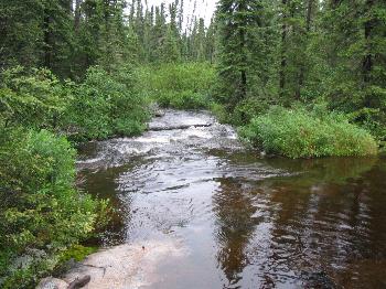
Lunch was at hand but the wind was so wicked that a rest was put off until the shelter of the trees on the last portage to Irvine could be reached. Up until now, my swimsuit and raingear had been sufficient for garments. The tarp went up well back in the trees and some warmer polypropylene got unpacked for the first time. After lunch and a lot of hot tea, the first trip to Irvine was attempted. The first passage went great but upon getting to Irvine, thick brush and marsh prevented getting to good water. By working parallel to the water, I got over to the creek that flowed from near my tarp back on the other lake. The stream from this point looked to be a good route on out to Irvine so my gear was left there. The stream was in a deep ravine but an easy way was found back up into the forest and back to my tarp. With this, another portage had been reborn. Certainly, people have been using this passage to Irvine for untold generations. After the last rapids, the stream did provide the best entry into Irvine Lake. It was brushy at first and then wound through a lazy channel in the grass to the open lake.
Copyright by Martin Kehoe, March, 2006 http://canoestories.com/kehoe/irvine1c.htm