 |
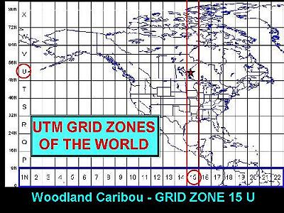
Slide 6 It's no surprise
that the cartographers of the world have a
system. The world is divided up into grid zones.
Woodland Caribou Park happens to be in grid zone
"15U". If you look carefully at one of
the topographic maps that covers the park, you'll
find a little information box that says: GRID ZONE DESIGNATION - DESIGNATION DE LA ZONE DU QUADRILLAGE: 15U Take a look at how far Woodland Caribou Park is from the equator. Notice that the park is a little to the left of the center of the grid zone. |
| We're going to find out that our topographic map, and our GPS receiver, reflects these distances. Right now, we're just going to use one of the North - South grid lines to help us line up our map. In the next lesson, we'll learn how to use the grid to specify a particular point on the map, and how our GPS receiver and the grid can show us exactly we are. |