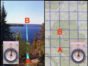
Maps - Compass - GPS
|
Maps and compass and GPS - we all know what they do. Why then in the year 2002 do we still get lost?
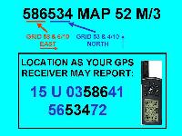 All of our navigation tools
come with directions. There's that little sheet that
comes with our Silva compass. The border of our map is
full of notes and diagrams and heck, a GPS receiver comes
with whole book of information! Can't we just throw it
all in our map case and figure it out when we get to the
end of the portage?
Well, no.
In order to use the wonderful tools so painstakingly developed by our distant and not so distant ancestors, we have to do a little studying. So here are some map and compass and GPS facts that you'll find very interesting - practical knowledge that you can use right now.
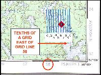
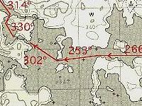 After you complete these lessons,
you'll have the knowledge to know where you are, and
where you're going. You'll learn how to use the Universal
Transverse Mercator Grid on your topographical maps.
You'll find out that you can plot out your entire trip
with magnetic bearings so you'll always know exactly
where to point your canoe. You'll learn how to set up
your GPS receiver so that the map and the receiver talk
the same language. Best of all, you won't have to kick
yourself like I did. I had to kick myself for not
learning this stuff years ago, when I could have used it!
The slides that
make up these lessons were part of a talk I did for a
canoe show in Wisconsin.  I gave a talk about Woodland Caribou
Park - that's why all of the examples are geared toward
Woodland Caribou. With a little reading and some
thinking, you should be able to adapt the information I'm
showing you to different parts of Ontario. Once you
realize how useful your maps and compass and GPS receiver
can be, you'll take the time to read more about maps and
the Global Positioning System. With experience, you can
easily adapt the knowledge to whatever part of the globe
you're going to travel.
Have a great time on your next canoe trip. I don't know where you're going, but if you read and practice, you're going to know exactly where you're going!
