|
Ontario's Woodland Caribou
Provincial Park - A Different World for Canoe
Travelers
The Story of a Solo Canoe Trip Through
Ontario's Woodland Caribou Provincial Park
By James
Hegyi
CHAPTER 1
To The End of the Road
|
|
"It's their last chance to see that
there's another world out here." I'm listening to Kim Markhausen as we
stand on the shore of Red Lake, near the western
border of Ontario, Canada. Kim and his wife Susan
own Black Bear Lodge, a fishing outpost that
caters each summer to hundreds of high school
students and their teachers. Together, for the
past twenty years, Kim and Susan have shown this
land to countless young people. I'm here because
Black Bear Lodge is also an entry point for
canoeists to the northern trails of Woodland
Caribou Park, to the eastern Bloodvein River.
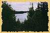
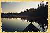
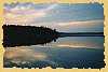
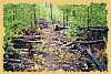
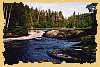
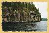
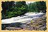
There IS another world out
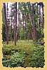
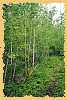
here. Over the last two weeks I've found a world
of fire scarred shores, of primitive muskeg
trails, of majestic islands, roaring waterfalls
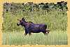
and quiet winding channels. It's home to beaver,
black bear, moose and woodland caribou. It's a
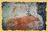
world where old pictographs send cryptic messages
from the people that once lived here, long ago.
It's a world that differs from Ontario's Quetico
Park, or the Superior National Forest of
Minnesota, a world of adventure, challenge and
abundance.
Although Kim and Susan provide
no services for canoe visitors, I immediately
felt a warm friendliness as I portaged my canoe
from the parking area to the lodge. I believe
it's Kim's attitude that the land is here for
everyone and the contagious excitement of the
lodge visitors that makes me like this place and
the people that keep it running. Kim tells me
that a canoe party in need is never turned away
from the Lodge. If the weather is bad and the
hour is late, room will be found in the bunkhouse
or a space will be found for tents. Soon I'm
driving back to civilization, and I start to
think about the challenging and exhilarating trip
that I've just finished...
|
|
There are eight
hundred and forty road miles between Milwaukee, Wisconsin
and Red Lake, Ontario. My canoe seems to dwarf my son's
old Toyota as I climb behind the wheel at six o'clock on
this Friday morning. In years past, I usually knew
exactly where I was going, exactly what I would run into.
This time, however, I'm not going to Quetico Park, my
usual destination, and I really don't know how the trip
will turn out.
By late afternoon, I pull into
International Falls, Minnesota. The town has a
no-nonsense look, a lumber yard on the main street seems
as right as the shops and motels that cater to visitors.
I don't have a good road map of Ontario, so I make a
quick trip to a gas station and buy one. Back at the
motel, I spread the map out on my bed and take a look.
Here is Red Lake, the last town I'll travel through, and
I see half of Woodland Caribou park on the top of the
map. I flip the map over, looking for the rest of
Ontario. I flip it over again - what the? Only half of
Ontario is shown on this map! Where's the northern half?
It takes a few seconds before I remember that I bought a road
map, and there are no roads beyond Red Lake!
 Early the next morning, I
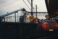
join the waiting line that forms at the Canadian border.
The line of cars creeps onto a steel bridge, right into
the workings of a Boise-Cascade processing plant. Early the next morning, I
join the waiting line that forms at the Canadian border.
The line of cars creeps onto a steel bridge, right into
the workings of a Boise-Cascade processing plant.
"Where are you going?" asks
the official as my turn comes.
"I'm going to Woodland Caribou
Park." I've read quite a few spy novels and know
that this is no time to get talkative.
"How long will you stay? What type
of guns do you have?"
"Two weeks. I don't have any
guns." Cameras roll and a strobe light flashes as my
picture is recorded. Evidently I look harmless enough and
I'm allowed into Canada. Immediately, I'm stripped of two
dollars and seventy-five cents as the toll for the bridge
I've just crossed. The border crossing ate up about
forty-five minutes.
Now the scenery improves as I follow
the road that snakes inland. The highway rises over Rainy
Lake, giving me a taste of rugged open landscape. The
clean, clear air is stimulating, making it seem that many
things are possible here. Soon I'm on route 502, heading
north again. Hours go by as the road cuts through solid
rock and the stations on my radio fade to static. Small
rock sculptures decorate the highway, tiny arches, shapes
of animals, some with pieces of wood or bone. Are these
small shrines? I don't know it yet, but in just a few
days I'll be depending on small piles of rocks to guide
me through a lonely, primitive wilderness path.
 Dryden appears, then for a
brief few kilometers, I'm on the Trans-Canada highway, a
route that extends the length of the country. The road
heads north again on route 105 as the sun climbs high in
the sky. Near Perralt Falls, a small bear cub loiters
near the road, completely ignoring the traffic that zooms
by. I'm amused by the "moose crossing" signs;
the pictures of moose here look malevolent, like an angry
bull moose in the middle of the rutting season. I make a
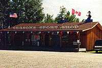
brief stop in Ear Falls, at the Four Seasons Sport Shop.
Permits are available here for camping in Woodland
Caribou Park. I also buy a seasonal conservation fishing
license. Dryden appears, then for a
brief few kilometers, I'm on the Trans-Canada highway, a
route that extends the length of the country. The road
heads north again on route 105 as the sun climbs high in
the sky. Near Perralt Falls, a small bear cub loiters
near the road, completely ignoring the traffic that zooms
by. I'm amused by the "moose crossing" signs;
the pictures of moose here look malevolent, like an angry
bull moose in the middle of the rutting season. I make a
brief stop in Ear Falls, at the Four Seasons Sport Shop.
Permits are available here for camping in Woodland
Caribou Park. I also buy a seasonal conservation fishing
license.
 Before
long, I'm in Red Lake, and turn left onto route 618. The
Ontario Government Building is closed today, so I
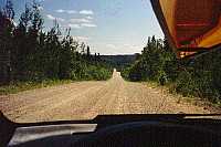
continue on 618 for 11 kilometers (6.8 miles) to Flat
Lake Road, a gravel road that leads into the forest. I
don't want to shake my son's car to pieces, so I slow
down to thirty kilometers per hour. Even so, the canoe,
solidly tied to the car for eight hundred miles, starts
to work loose and slip off the top. It takes forty-five
minutes to drive the seventeen and a half kilometers
(eleven miles) of gravel road to Black Bear Lodge. Before
long, I'm in Red Lake, and turn left onto route 618. The
Ontario Government Building is closed today, so I
continue on 618 for 11 kilometers (6.8 miles) to Flat
Lake Road, a gravel road that leads into the forest. I
don't want to shake my son's car to pieces, so I slow
down to thirty kilometers per hour. Even so, the canoe,
solidly tied to the car for eight hundred miles, starts
to work loose and slip off the top. It takes forty-five
minutes to drive the seventeen and a half kilometers
(eleven miles) of gravel road to Black Bear Lodge.
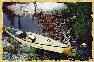
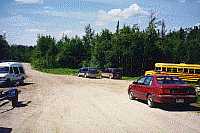 The "parking lot"
is really just a widening in the gravel; a slate colored
one-lane road leads to the lodge. I learn from some other
visitors that all vehicles are left here on the road, and
that I should walk to the lodge. Susan Markhausen is in
the lodge kitchen, and we talk for a minute or two about
the park. I hitch a ride on the lodge tractor and get a
free ride back with my pack. Another trip for the canoe,
and I'm ready to start my trip. The "parking lot"
is really just a widening in the gravel; a slate colored
one-lane road leads to the lodge. I learn from some other
visitors that all vehicles are left here on the road, and
that I should walk to the lodge. Susan Markhausen is in
the lodge kitchen, and we talk for a minute or two about
the park. I hitch a ride on the lodge tractor and get a
free ride back with my pack. Another trip for the canoe,
and I'm ready to start my trip.
Copyright
1998 by James A. Hegyi
http://wwwcanoestories.com/wood1f.html
|