|
Lost portages of Irvine
Lake A solo canoe trip into Woodland Caribou Provincial Park by Martin Kehoe Part 8 Moose Lake - "Dandy Lake" - Dunstan Lake - Wanda Lake GPS Waypoints Listings at the bottom of the page |
|
Lost portages of Irvine
Lake A solo canoe trip into Woodland Caribou Provincial Park by Martin Kehoe Part 8 Moose Lake - "Dandy Lake" - Dunstan Lake - Wanda Lake GPS Waypoints Listings at the bottom of the page |
| Go
to Part: 1 2 3 4 5 6 7 8 |
More Canoe Stories |
Maps for this trip |
It is moving day again and an early day is possible with yesterday’s restful schedule. There is a heavy mist lying on the lake, so thick the muted sun can be stared at through it. The camp is broken and the canoe loaded in time to enjoy a paddle through the lingering mist dancing across the waters of the big Moose Lake.
 The mood is dampened when an old camp is spotted on the north shore. It has a great view but the past campers have broken most rules of leave no trace camping. Nails hold a makeshift table together and poles to the trees. An old shoe, a bottle labeled "Oil" and tattered garbage bags covering kindling show someone had good intentions but never got back to the camp. The firewood appears to have been cut years ago and the massive fire
ring has no black coals, just rusty tin lids.
The mood is dampened when an old camp is spotted on the north shore. It has a great view but the past campers have broken most rules of leave no trace camping. Nails hold a makeshift table together and poles to the trees. An old shoe, a bottle labeled "Oil" and tattered garbage bags covering kindling show someone had good intentions but never got back to the camp. The firewood appears to have been cut years ago and the massive fire
ring has no black coals, just rusty tin lids.
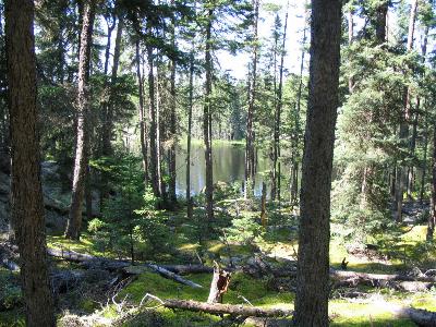
Near the trappers portage a sawed stump led me to investigate a spot. A few black coals showed that someone had used the sheltered spot to warm up in recent times. The trapper’s portage made for an easy trek to the next lake. Three beavers are working as the first load is set down near their dam. They show as much concern as a moose did a little while ago out on Moose Lake. The lake has a band of Muskeg around it with one exception. There is a rock wall with water cascading down its face. A quick scan shows no blazes so the trapper must have stopped at the dam. A route is chosen up the wall on the north side of the waterfall. A steep climb needs a few switchbacks to get to the top where it then climbs easily to the next lake a short distance away.
 |
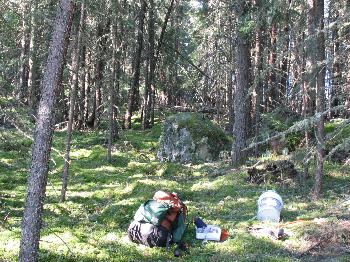
 |
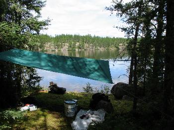
| looking at the wall from under my tarp | A grand camping spot |
Five minutes into my paddle up the lake and I know that this has to be home for tonight and maybe tomorrow too. The lake is so rife with grand camping spots it is hard to decide on one. The one picked looks out on a rugged thinly treed long rock wall. Even with a rainy day, I could enjoy gazing at that wall from under my tarp. The lichen and moss is all torn up near my camp and the thought of Caribou is taken over by bears when all the little red berries are spotted amongst the moss.
 In the middle of the afternoon, the canoe is outfitted for exploration, fishing and fixing supper. Trolling with Old Pinkie, two Northerns are on the stringer for supper before traveling very far. The short portage to the next lake is like picking a campspot on the lake, too many good choices. After several trips across the portage with each one being a little better than the last, one more is tried that is used by the animals. At the far shore and only inches from the water is a 12 inch Jack Pine with a very old and extremely deep blaze cut in its side. It is so close to the water that it must have escaped the last fire to burn the area.
The fish fries are getting better each time. After trying different techniques and cuts, the Northern fillets are coming out completely free of bones. There are a half dozen Herring Gulls on the lake but they do not connect my fish cleaning to a free meal. They must not travel much from this isolated lake. The number of crows is surprising too. A Greater Yellow Legs shares the gulls nest rock with them today. Bedtime comes with thickening clouds and thunder well off in the west.
During the night, a "Perfect Storm" for a camper moves through. The thunder is far away, the wind does not blow and the sun is shining in the morning. It was good to have the rain. This country gets tinder dry so fast that frequent rains are helpful in keeping the fire danger in check. It only takes one hot windy day to turn wood that will not burn into kindling that burns so hot it will drive you back from a small campfire. For this reason, Manitoba does not allow open campfires.
The time has flown by and my trip is down to its last week. Travel and exploration has gone so well that I am dragging my feet to stay in the backcountry as long as possible. The weather is perfect but this lake is home for one more day anyway. This is a "Dandy Lake" and has been temporarily named that just so there is a name to refer to it by. It is a perfect place to spend some extra time. The noisy gulls and calling loons add a lot to life on this lake. A missing element is young loons with their parents. The wet June may be the culprit as there has not been one young loon swimming with the adults on the entire trip. A hike in the woods behind camp was quiet on the wet moss. An abundance of tracks proved that the animals were there but not seen. Spruce grouse, Moose and Caribou droppings were found during the hike. At one spot, the dewclaw imprints of a Caribou could be seen imprinted in the wet moss. A paddle to the previous portage was fruitful as well. In searching for any old portages it was discovered that the map had the creek passage in the wrong place. That provided for a much nicer portage route on the south side of the stream.
 |
 |
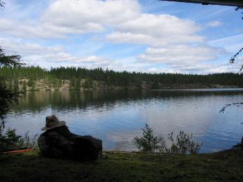
| traill to the next lake | A campspot on the lake before Dunstan |
The dance troupe of loons performing on the lake stage has increased to seven performers. For my dinner entertainment, they put on an interesting display of water ballet while providing their own musical accompaniment. My favorite is the pirouette with the loon rising straight up out of the water and tap dancing the surface to stay there.
As the expedition is loaded up and heads for the portage the morning sun is putting everything in its best light on Dandy Lake. It is a very slow trip to the short portage to the next lake in the journey. My feet are really dragging now, trying for a little longer in here.
The next lake is a fine lake also but the next time through my camp will still be on Dandy Lake. The next portage is approached and instead of an old blaze mark, there is an eight-meter wide channel leading to the next lake. It cannot get any easier than that. The plan is to camp on one of the many campspots here but first a peek into the next small lake, the last one before Dunstan. That peek shows me a campspot near where my last lost portage will be sought out. Camping there will allow me to explore and lay out the last portage very easily.
It is a relief to see a lot of good rock in the area of the final portage out to the regular canoe route that connects the Bloodvein and Gammon River systems. The canoe is not even unloaded before a trip to Dunstan is made. It is a terrible passage but a great way is found on the way back. With this last portage penciled in this has turned into a very easy and scenic way to travel from Simeon Lake to Moose and then through five more portages totaling only 1200 meters to get to Dunstan.
My final day in the backcountry starts out sunny and hot. Even at 7:00 am, the big rock at my camp is too hot to enjoy breakfast. Things are packed for a two-trip portage. Every portage had been a triple until now. The weight would have allowed double portaging a week ago but for safety reasons triples were my self-imposed rule. The carries go well and on one pass an old blaze on a fallen tree is spotted as I step over it. It was fitting that the last portage was lost, but now is found. It is now time to reenter the civilized area of the park. One consolation is that remote Dunstan Lake should allow me to ease back in gradually.
The 800-meter portage at Dunstan is always a great hike in a pretty area. The stream on the way to Wanda has had many of its banks undercut with the recent floodwaters. The portage was pretty much gone. Between the beaver’s damage and the floodwaters, it was easiest to stay off to the side of the old route. As I paddled the switchbacks to Wanda, a big engine revving up could be heard. When I paddled into open water, a modern twin-engine floatplane was taxing down wind in preparation for takeoff. Well, welcome to the civilized world.
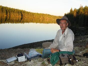
It had been three weeks since an encounter with a human being so the meeting with the float plane made me realize how special the backcountry travel had been. A two-day stay on Wanda helped me recover from the jolt and ease back into there being other people around. The lake is not visited much and made for a relaxing time. There was no one there during my stay and the weather was fantastic. The next move was past Terry Lake and across Carroll where motorboats were heading out to fish when I crossed to the Haggart River. It had not rained much in the last few weeks but the river was still a dangerous place to travel. The river is all right but getting near the portages was sometimes impossible to do. Rock walls limited the options for surmounting the problems. There is not much in the way of campspots but being alone I only needed a small area for my tent so was able to spend two nights on my way to the portages to Broken Arrow Lake. My first canoes in over three weeks came by as I was fishing from a rock at one of these. They were more surprised than me and had seen no one since their start on the east side of the park a week earlier. A camp was selected on Crystal for the last night because I still wanted to enjoy all the solitude possible before paddling out to Wallace Lake.
The trip exceeded my wildest hopes in the great times experienced. "Lost Portages" have a special allure for me now. Because of the lack of underbrush, the travel through the woods was very easy unless the wind had blown down most of the trees. The areas blown down in my travels were always small and usually only where the wind came off a bigger lake. A medium sized bow saw was used more on the maintained portages than in the backcountry. A GPS with topo maps loaded in really made navigation a simple matter. The paper topo maps were in my pack as a backup but were rarely used except at camp as a broader study of the region was done. The GPS coordinates of my travels are included at the end of this story. It must be remembered that there is a lot of risk involved in a trip like this. I cannot stress enough that the placement of every footstep is important. The satellite phone is a necessity for a solo trip such as this. I think of it as buying an insurance policy for the trip. It is expensive and you hope you do not need to use it. In the true sense of going solo, you have provided for your own welfare. I hope you have enjoyed the journey and that it will help you take the next step in your adventures. I would be glad to answer any questions you may have if you want to come and enjoy Woodland Caribou Provincial Park.
GPS coordinates - Waypoints Listing:
20 Meter Portage Lake to
Larus Creek
Blue Green Lake north of
Royd Lake to Irvine Lake
Irvine Lake to Royd-Murdock
canoe route
Moose Lake to Dunstan Lake
Listing of all waypoints for
this trip
Garmin Database File (.gdb) for this trip
(RIGHT CLICK AND SAVE)
| Go
to Part: 1 2 3 4 5 6 7 8 |
More Canoe Stories |
Maps for this trip |
Copyright by Martin Kehoe, March, 2006 http://canoestories.com/kehoe/irvine1c.htm