| Slide 21 Now a few things
might occur to you after thinking about maps and
canoes and magnetic bearings. Sometimes you sleep
on these things, then at three in the morning you
jump up and shout "Eureka!" That's
generally what happens to me, and I have to admit
that my wife is starting to get pretty annoyed
with it. So to save you some sleep,
I'll pass a few of these "thunk up"
ideas to you right now.
- If
you line up the white (south) needle of
the compass with the orienting arrow, you
can go in exactly the opposite direction.
If, for example, you're going in and out
of the park along the same chain of
lakes, you really only need to plot your
course once. When you're up in the park,
sitting in your canoe, align the red
(north) needle inside the orienting arrow
when you're going in and, using the same
bearing settings, align the white (south)
needle when you're going out.
- Your
paper maps aren't waterproof, but you can
make them water resistant. You can buy
clear Krylon fixatif - it's a coating
sold to artists who make charcoal
drawings. A few thin coats on each side
of the map seals the paper so that it
won't fall apart when it gets wet. If you
can't find the fixatif, clear Krylon
spray is just about as good. Try it on a
small area of your map to see if it makes
the ink run.
- I
consider a map to be an essential part of
my outfitting. Since an extra map doesn't
weight very much, I usually carry two
copies. I start by making copies of
sections of my topo maps at 150% on
11" X 14" paper. I then
transfer the UTM Grid Lines from my topo
map to my copies. I also transfer the Map
Number (example: 52 M/1). Next, I get out
a magnifying glass and carefully transfer
the portages and portage distances from
the Park Map to my topo map copies. Then
I line up my copies, tape them down, and
add in Magnetic Bearings. Finally, I give
them each a coat of Krylon, front and
back. One copy goes in my map case, along
with the Park Map, one copy goes in my
pack that doesn't have the food in it.
- If
you carefully hide your maps and compass
from your partner in the bow, you can
sneak a look at them when he or she isn't
watching, then dramatically stop the
canoe and call for complete silence. When
your partner looks back at you to see
what's the matter, you can
"feel" the air, smell the wind,
and dip your hand into the water before
announcing exactly the correct direction
to the next portage landing. For the more
practical traveler, you could explain
your "secret" system, thereby
insuring that your partner could drag you
back to civilization should you manage to
tweak your bad back into a knot while
landing that giant Jackfish.
 I talked about
Woodland Caribou Park, and used examples from the
park to explain the method of marking bearings.
All right, I admit it, I started doing this with
my McKenzie maps when I traveled in the boundary
waters. Hey, I had to do it, I was always getting
myself lost. You can too. The declination for the
Superior National Forest and Quetico Park is
close to 0 degrees right now. If you set your
compass dial to 0 degrees (SLIDE 11) and line up
the edge of the compass with the
"North" arrow on your Fisher or
McKenzie map, you can chart your course just as I
do with my topographic maps. I talked about
Woodland Caribou Park, and used examples from the
park to explain the method of marking bearings.
All right, I admit it, I started doing this with
my McKenzie maps when I traveled in the boundary
waters. Hey, I had to do it, I was always getting
myself lost. You can too. The declination for the
Superior National Forest and Quetico Park is
close to 0 degrees right now. If you set your
compass dial to 0 degrees (SLIDE 11) and line up
the edge of the compass with the
"North" arrow on your Fisher or
McKenzie map, you can chart your course just as I
do with my topographic maps.
Now if you're going to travel in Wabakimi Park,
the declination is only 2 degrees East. You would
set your compass for 358 degrees (SLIDE 11).
In
Algonquin Park, near the eastern border of
Ontario, your declination will be close to 10
degrees West, not the 5 degrees East of Woodland
Caribou Park. To align your Algonquin map for
taking magnetic bearings, you would have to set
the dial on your compass to 10 degrees (SLIDE 11)
instead of the 355 degrees we used for aligning
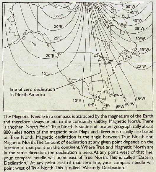
the Woodland Caribou map. Take a look at the map
above. This map came with my Silva compass and it
illustrates and explains why the declination
changes:
Hey, you read this whole
thing! Not only did I save you some sleep, I probably put you to
sleep. Sleep is good. Think about the things I've shown you,
sleep on it, and then get a map and give it a try. If you have
any questions, or would like me to give you a reality check,
send me a letter.
|