 |
Slide 4 Here's how we would
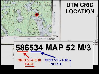
state the position of our spot on the map: 586534 MAP 52 M/3 We're 6/10 of a grid EAST of grid line 58. This distance is called the "Easting." We're 4/10 of a grid NORTH of grid line 53. This distance is called the "Northing." This UTM GRID LOCATION is a shorthand method of specifying a spot |
| within
about 100 meters or so. It's a way of saying
"if you have the same map I do, here's the
spot I'm showing you." Now that you understand this shorthand method of specifying a point on a map, you'll be pleased to know that each Canadian topographic map has an information box that explains it all over again. Cartographers aren't very wordy people, so they won't say "hey, chuck, here's a dandy way to reference a point on this here map." Instead the note will say: "EXAMPLE OF METHOD USED TO GIVE A REFERENCE TO NEAREST 100 METERS." |