 |
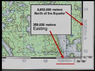
Slide 7 This is all
starting to make sense now. Our topographic map
is telling us that Easting Grid Line 59 really
means 359,000 meters (or 359 kilometers). It's on
the left or west side of Grid Zone 15U, west of
the 500 kilometer grid line in the middle of the
grid zone. Of course Easting grid line 58
therefore really means 358,000 meters. Northing Grid Line 53 really reads 5,653,000 meters (or 5,653 kilometers) North of the Equator. The map makers show the true value of |
| one grid line, then just mark the kilometers for the rest of the grid lines. The actual values of the grid lines are important when we use a GPS receiver. We'll understand that pretty soon. |