 |
Slide 8Before you can use
your GPS receiver to find your position on the
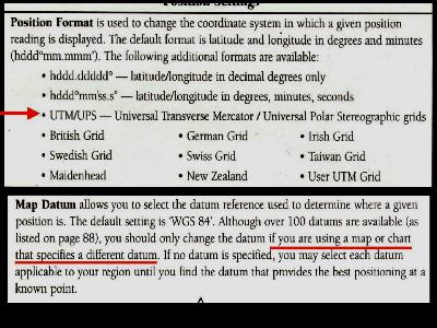
map, you have to enter some settings. The first thing your receiver wants to know is "What format do you want me to use when I display your postion?" In our case, we're using Universal Transverse Mercator (UTM) maps so we want our position in the same format. The second thing your receiver wants to know is "What Grid are you using?" There's more than one, and your GPS |
| receiver will give inaccurate readings if you don't set it to match the one used on your topographical map. Most of the current maps for Woodland Caribou Park use the 1927 Grid (or DATUM). If you look at your map, it will tell you what grid datum was used when the map was made. |