 |
Slide 12 You remember the
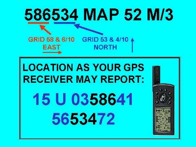
UTM "shorthand" method of showing our
spot on the map. That's at the top of this slide. Now that we know the true value of the kilometer grid lines, we can see that our GPS accurately shows us our position. There's our Grid Zone 15U, and our position on the grid in kilometers: 358.641 kilometers on the Easting Grid. 5,653.472 kilometers North of the Equator. |
| There's
no map number displayed by the GPS because it
doesn't care about anyone's map system. Remember
this if you make copies of parts of your map to
use on your trip. When you transfer the grid line
numbers from the original map to your copy, you
should also show the true value of at least one
Easting and one Northing grid line marker. Also
copy the map datum (NAD 27, NAD 83 ...). Then
you'll be able to coordinate your GPS reading
with your map. Beware that your map datum can and
will sometimes change. Maps are updated, and new
issues can use the newer datum. That's it for the GPS. It's actually very easy to read, once you understand what it's trying to tell you. The maps have all the information you need if you know what to look for. And now you do! |