 |
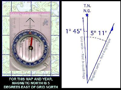
Slide 8 If you again look
closely at one of the topographic maps for the
park, you'll find either a diagram like the one
on the left, or an information note that might
read: The 1995 MAGNETIC BEARING is 5 degrees 11 minutes EAST of GRID NORTH ANNUAL CHANGE DECREASING 7.6 minutes. The diagram or note is telling us that the angle between Grid North and Magnetic North is 5 degrees and 11 minutes. It's also telling us that |
| Magnetic
North is East of Grid North. It's also telling us
the rate of change. That's right - magnetic north
is not always in the same place! It changes from
year to year. In this example, the map is telling
us that the angle is decreasing by approximatily
7.6 minutes per year. Let's see now, there's 60 minutes in each degree, and it's 6 years later now than 1995, so we subtract (6 years X 7.6 minutes) or 46 minutes from 5 degrees (300 minutes) and 11 minutes. That's 311 - 46 = 265 minutes or 4 degrees 25 minutes. Now keep two things in mind. Thing 1: If our map was published 25 years ago, we might be a few degrees off if we blindly use the information on the chart. Thing 2: We're not piloting the Exxon Valdiz here, we're pointing our canoe at a portage! Let's not get real picky about where magnetic north is! In fact, I'm going to use 5 degrees for the rest of this lesson. |